Back Somerset-Wes Afrikaans سومرست ويست Arabic Somerset West German Somerset West English Somerset West Esperanto Somerset West French Somerset West Italian Somerset West Dutch Somerset West NB Somerset West Polish
| Somerset West | |
|---|---|
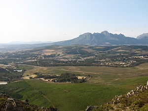
 Aerial view of Somerset West with Hottentots-Holland Mountains in the background | |
|
Location within Cape Town Lua error in Module:Location_map at line 417: Unable to find the specified location map definition. Neither "Module:Location map/data/Cape Town" nor "Template:Location map Cape Town" exists. | |
| Coordinates: 34°02′S 18°51′E / 34.033°S 18.850°E | |
| Naga | Afrika Borwa |
| Porofense | Kapa Bodikela |
| Mmušôselegae | City of Cape Town Metropolitan Municipality|City of Cape Town |
| Hlômile | 1822 |
| Sekgôba[1] | |
| • Total | 61.37 km2 (23.70 sq mi) |
| Setšhaba (2011)[1] | |
| • Total | 55,166 |
| • Phitlaganyo | 900/km2 (2,300/sq mi) |
| Dipersente tša merafe (2011)[1] | |
| • Bathobaso | 13.0% |
| • Bammala | 24.5% |
| • MaIndia | 0.9% |
| • Makgowa | 60.1% |
| • Šele | 1.6% |
| Dipolelo tša ntlha (2011)[1] | |
| • Afrikaans | 52.3% |
| • Seisimane | 37.5% |
| • Sethosa | 4.8% |
| • Šele | 5.3% |
| Nomoro ya poso (Setarata) | 7130 |
| Nomoro ya poso (Lepokisi) | 7129 |
| Khoutu ya lefelo | 021 |

Somerset West ke toropo hleng la Cape Town, Kapa Bodikela.
- ↑ 1.0 1.1 1.2 1.3 "Main Place Somerset West". Census 2011.
